
Trace a Copperas Cove Street
A street-by-street search starts by tying a postal-style address to the land record behind it. Copperas Cove lies mainly in Coryell County, yet the city reaches into Lampasas and Bell Counties. Confirming the parcel county comes before using an appraisal district, clerk, or tax office. For a Coryell address, the current appraisal account, parcel map, city plat index, and County Clerk index form a practical sequence. Each source should be read as evidence for its own purpose, rather than as proof of every occupant.
Keep the exact situs address, property or geographic ID, subdivision, lot, block, and legal description together. A situs address is the parcel location. A legal description identifies the land interest recorded in a deed. Those details travel better than an abbreviated street label when names, road formats, and county routes differ.
- Check the Copperas Cove city plat index or a parcel map for the address, county, subdivision, lot, and block.
- Search Copperas Cove’s Coryell CAD route by street number and simple street name, then save the property or geographic identifier.
- Use the Copperas Cove CAD GIS view to inspect the subject parcel and nearby parcel labels at street scale.
- Carry the Copperas Cove owner clue and legal description to the County Clerk eDoc index, which searches people, dates, and instrument numbers.
- Use Copperas Cove permits and a verified historic directory volume as dated supporting evidence, not as title proof.
Note: For any Copperas Cove address near the city edge, the plat’s county field should decide the first county-records route.
Confirm a Copperas Cove Street County
County geography is the first local test in a Copperas Cove street directory. The city Plat Files index lists an address with its county, property ID, subdivision, lot, and block. It is a useful bridge from a familiar street number to the correct public custodian. It is not a deed and does not certify title.
The Georgetown Road entries show why this check matters. The index marks 1404 Georgetown Road in Lampasas County, while nearby 1406 and 1228 are marked Coryell. An address with a Copperas Cove mailing city can therefore lead to a different appraisal, deed, tax, or court route. Bell County can also be relevant in the city’s northwestern municipal area. When the county changes, stop and use that county’s custodian instead of forcing the parcel into a Coryell search.
- Parcel
- A Copperas Cove mapped unit of land used by the appraisal district and map system.
- Situs address
- The Copperas Cove parcel or building location used for maps and address-keyed city records.
- Plat
- A Copperas Cove recorded or indexed map that can connect an address to a subdivision, lot, block, and county.
- Criss-cross directory
- A Copperas Cove reverse-style directory arranged by address, when a verified volume exists, rather than by surname.
Search Copperas Cove Street Parcels
Coryell Central Appraisal District’s property search is the main current address route for a Coryell County Copperas Cove street. Its help advises an address search using a street number and simple street name, without directional prefixes, suffixes, or unit details on the first pass. An owner search accepts Lastname, Firstname or Lastname Firstname. A street-name-only search broadens the result set when the number is uncertain.
The appraisal record can supply an owner name as shown, situs and mailing fields, property or geographic ID, legal description, subdivision or lot/block detail, tax year, and possible exemption information when a result exposes them. Treat the record as a current appraisal and tax clue. A tax mailing address may belong to an estate, company, manager, relative, or an owner who lives elsewhere. A homestead flag is evidence consistent with owner occupancy for that tax year, not a household count.
| CAD field | Input type | Street-directory use | Format or limit |
|---|---|---|---|
| Owner Name | Text | Checks a known Copperas Cove owner against an appraisal account. | Last Name First Name or Lastname, Firstname. |
| Street Number and Street Name | Text | Finds a current Copperas Cove address record. | Use a simple street name first. |
| Property ID and Geographic ID | Text | Reconnects a Copperas Cove map label to an appraisal account. | Identifier search. |
| Subdivision and Neighborhood | Autocomplete | Narrows a Copperas Cove street search. | Select a matching value. |
| Tax Year and Property Type | Select | Refines annual appraisal results. | Complete option lists were not exposed. |
Note: CAD reports legal descriptions and acreage for appraisal use, so a disputed boundary or title question belongs with the proper record custodian.
Browse Copperas Cove Street Parcels
The Coryell CAD GIS viewer adds the map layer to a Copperas Cove street search. Use Search Here for an address, parcel, or map term, choose a suggested match if one appears, and zoom until parcel boundaries and labels are visible. Clicking the subject parcel and adjoining parcels can reveal the account or geographic clue needed to return to CAD. Pan along the street instead of assuming the first match covers the whole block.
Map lines are approximate and the GIS alone does not provide ownership or value. The reliable join is map label to CAD identifier, then CAD record to legal description. The viewer shows Home, zoom, locate, back and forward extent controls, and visibility controls. A complete layer menu, a street-wide export, and a public buffer tool were not verified, so none should be assumed. City planning maps can add boundary context but do not replace the CAD parcel view.
Follow Copperas Cove Street Deeds
Once CAD supplies a legal description and an owner clue, use the Coryell County Clerk eDoc document search for the recorded instrument trail. The captured form has Date From, Date To, Person Full Name, Instrument No, and Records Per Page fields. It accepts partial names and does not show a dedicated street-address field. Search the owner as a grantee, identify the purchase instrument, then read the seller or grantor and search that name in an earlier window.
The documented eDoc screen for the Copperas Cove street directory shows the date, name, and instrument routes available to a researcher.
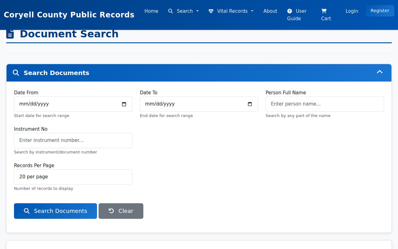
The screenshot is a search-form reference, not evidence that every recorded deed image or result field is freely available. The public page does not state an online start year, and a qualifying result sample was not accessible during research. When an image is gated or a certified copy is needed, contact the County Clerk at the Gatesville counter, by phone, mail, or the portal’s available account route.
A deed is the title record, while an appraisal record is a tax and valuation record. The legal description, grantor and grantee pairing, and instrument date are stronger continuity checks than a street name by itself. For one property’s earlier occupants or directory evidence, the separate Copperas Cove City Directory resource focuses on historical collections.
Copperas Cove Street Record Layers
Different address-keyed sources answer different questions. Combining them avoids a common error: calling a map an owner list or calling a permit an occupancy record. The table below keeps the street directory trail focused on the actual public channel for each record and the limit attached to it. That street directory method keeps a current parcel clue separate from a dated legal or household record.
| Address record | Street value | Copperas Cove access route | Important limit |
|---|---|---|---|
| City plat file | County, property ID, subdivision, lot, and block. | Public indexed plat PDF. | Jurisdiction check, not title proof. |
| CAD appraisal roll | Owner, situs, mailing, IDs, appraisal context. | CAD web search or Copperas Cove CAD office. | Current appraisal clue, not a full resident roll. |
| CAD GIS | Parcel shape, abstract context, adjacent parcels. | Public map browse. | Approximate boundaries and no ownership by itself. |
| County instrument index | Grantor, grantee, recording trail, legal description. | eDoc search, County Clerk counter, or historical microfilm. | Online cutoff and image access are not stated. |
| Permit report | Address, work, date, and possible applicant field. | Monthly city reports and Building Department route. | Not a complete record of people at an address. |
| Voter data | Registration and geography for a matched person. | Texas lookup or lawful SOS file request. | Not a public street-wide household roster. |
The Texas voter lookup can help confirm a matched individual’s registration status and geography, subject to suppression rules. It cannot be turned into a casual street census. When the official lookup does not return a match, the Coryell County Tax Assessor-Collector and Voter Registrar is the local assistance route. A full statewide file request has affidavit, payment, and use restrictions documented by the Secretary of State.
Date a Copperas Cove Street
Copperas Cove permit reports are monthly Building Development Permit Report PDFs and provide dated address evidence for construction or alteration. When a report shows it, preserve the permit number, date, address, project description, and applicant or owner field. Compare the address with the CAD situs and the plat’s lot/block rather than treating an applicant name as proof of who lives there.
For older or more specific city material, the Building Department and City Secretary can route a targeted Texas Public Information Act request. Identify the address, department, record type, and date range. The research did not find a complete searchable public permit or code-case database. A request or counter inquiry is therefore the documented fallback for older, address-specific city records, while municipal court files follow their own judicial-records process.
Copperas Cove Street Directory History
Reverse or criss-cross directories are the historic address-to-name layer of a street directory. A verified volume may arrange entries by address and show a name, phone number, and sometimes spouse, occupation, or owner-renter notation. Copperas Cove’s exact residential or reverse-directory year run was not verified in the public sources. That gap matters: do not assign a year range to a local shelf until the holding institution confirms it.
The practical fallback is to ask the Copperas Cove Public Library whether it holds city directories, telephone books, reverse directories, yearbooks, local obituary indexes, or newspaper microfilm for the requested year. Its Biblionix catalog is a discovery tool, and TexShare access can be card-gated or in-library. TSLAC’s on-site directory holdings, UNT’s digitized Texas collection, and UT Briscoe’s collection-level directory resources are additional routes. Preserve the page image, directory title, publisher, year, page, and abbreviation key when a match is found.
Note: A directory entry is a dated compilation, so its address line should be paired with a parcel, deed, or census source before drawing conclusions.
Copperas Cove Street Roll Eras
The record timeline is uneven, which is useful to know before a Copperas Cove street search begins. Coryell CAD links historical appraisal rolls for 1990 through 2026. Coryell tax-roll microfilm reaches 1855 through 1910. Coryell deed records on the documented Baylor and Texas State Library and Archives Commission microfilm route cover 1852 through 1905, with deed-of-trust material from 1854 through 1901. These are research-era anchors, not a continuous resident list.
Between sources, carry forward the legal description and test the next available record type. The County Clerk eDoc index has no published online first year. Older deeds may require the clerk, Baylor, TSLAC, a depository, or a FamilySearch access route. The county clerk remains the certification custodian, while research microfilm supplies a way to locate older books. This distributed trail is more reliable than assuming an absent web result means an absent record.
Read Copperas Cove Street History
Older street research needs a place-name check as well as a parcel check. The post office began as Coperas Cove in 1879, the community moved about two miles northeast after the railway reached the area in 1882, and the spelling became Copperas Cove in 1901. An early deed, census entry, or newspaper item can therefore use Coperas Cove, a county precinct, a rural route, or a nearby post-office description rather than the modern address format.
Search both spellings and keep the original wording beside the record. The documented railway move is a continuity warning, not evidence of a confirmed city street-renumbering project. No official source located a Copperas Cove street-renumbering year or a single E911 addressing authority. Legal descriptions and lot/block references are the safer bridge across older records.
Limit a Copperas Cove Street Search
A Copperas Cove street directory cannot show every person connected to an address. Utility customer lists are not an open resident list. Motor-vehicle address information has federal privacy limits. Protected voter addresses and Texas Address Confidentiality Program participants may be suppressed, and sealed or restricted records remain unavailable. A current tax owner can also be an estate, trust, company, or person whose mailing address is elsewhere.
Use address records for lawful family-history, estate, consumer-safety, civic, or property-curiosity research. Verify important facts with the office that holds the record and date each result. Texas Public Information Act requests are targeted requests for releasable government records, not a route around privacy protections.
Lawful use. Copperas Cove street records support personal, lawful research; never use an address trail to stalk, harass, intimidate, or harm anyone.